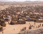
For the first time, the population of an entire city has been estimated from space through a pioneering project to speed up medical and disaster relief efforts. By analysing satellite images of disaster zones and famine, war or disease-hit areas where census data is unreliable, or cities unreachable, researchers hope to make rapid and more accurate estimates of how many people might need help.